
Madison County, IN
Cemetery Information by Township:
Many of these links will refer you to the pages of the Madison County Cemetery Commission website that has lots of fantastic information.
MONROE TOWNSHIP [Alexandria, Orestes, Gilman]:
Click on the cemetery below to see a list of pioneer burials, history, bits of biographies, and pictures.
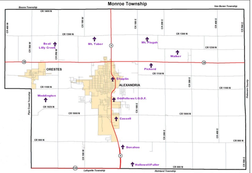
CREDIT to the Madison County Cemetery Commission for the following interactive map!
Pioneer Cemeteries:
Alexandria Graveyard (Destroyed)
SE corner of Harrison & 4th Sts. in Alexandria /GPS N40.15.345; W085.35.457
---------------------------------
W side of CR 200W, between SR 28 & CR 1300N/GPS N40.17.133; W085.42.567
---------------------------------
N of CR 900N, 1/2 mile E of SR 9 (No GPS Available)
---------------------------------
E side of Harrison St., between Monroe & Jackson Sts. in Alexandria /GPS N40.16.090; Wo85.40.434
---------------------------------
E side of SR 9, between SR 128 and CR 900N /GPS N40.13.406; W085.39.864
---------------------------------
N side of SR 128 (CR 800N), between SR 9 & CR 150E/ GPS N40.13.595; W085.39.651
---------------------------------
E side of SR 9, between 4th & 5th Sts./ GPS N40.15.278; W085.40.164
---------------------------------
S side of CR 1300N, between CRs 100E & 175E/ GPS N40.17.618; W085.38.616
---------------------------------
S side of CR 1100N (Bethel Rd.), between CRs 300E & 400E/ GPS N40.15.214; W085.35.716
---------------------------------
S side of SR 28, between CRs 100E & 200E/ GPS N40.11.515; W085.39.765
---------------------------------
1/2 mile W of SR 9, S side of CR 1300N /GPS N40.17.506; W085.40.728
---------------------------------
S side of CR 1250, between CRs 300E & 350S /GPS N40.17.038; W085.36.640
---------------------------------
W side of CR 200W, between CRs 1025N & 1100N (on Bowers Farm) /GPS N40.15.424; W085.42.878
---------------------------------
Other Cemeteries:
Alexandria, Madison County, Indiana